Still using spreadsheets to manage your territories?
You’re probably trying to make sense of scattered sales data but keep hitting walls with clunky mapping tools and manual reporting.
But the truth is, wasting hours manually updating maps makes it almost impossible to quickly spot market gaps or uncover sales trends.
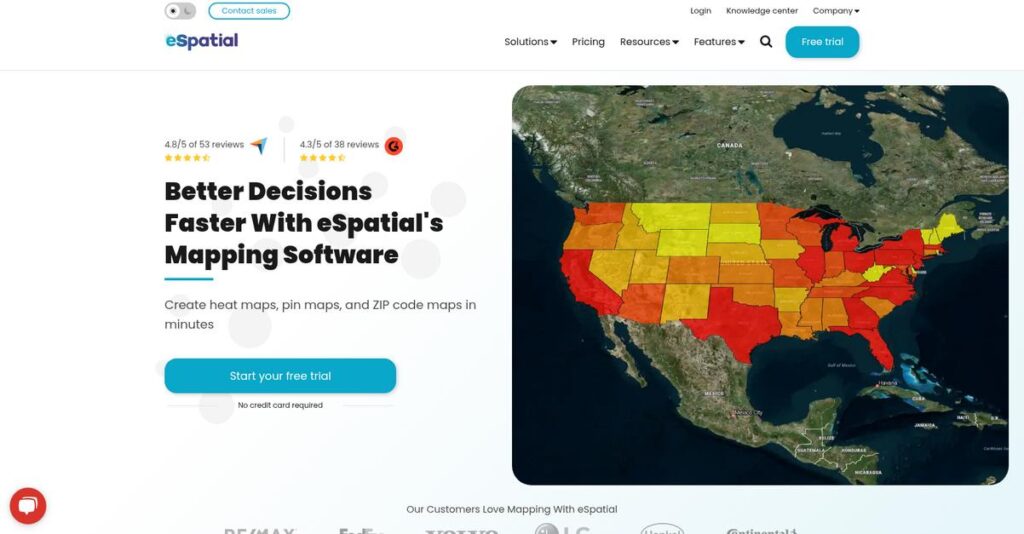
eSpatial actually fixes this by giving you lightning-fast mapping, territory optimization, and data visualization, so you can see exactly where to focus—without endless admin headaches or guesswork. You can even pull in Salesforce data instantly and share findings with your team or leadership in just a few clicks.
In this review, I’ll break down how eSpatial lets you unlock answers faster—from first-time map setup to advanced territory planning.
In this espatial review, I’ll show you how the platform’s features actually work, what pricing to expect, who it’s best for, and how it stacks up against rivals.
You’ll get the insights you need to pick the features you need to make decisions confidently and streamline your own process.
Let’s get started.
Quick Summary
- eSpatial is a cloud-based mapping tool that helps sales, marketing, and operations teams visualize and analyze location data.
- Best for businesses needing easy-to-use territory management and route planning without deep GIS expertise.
- You’ll appreciate its intuitive interface combined with strong territory optimization and seamless Salesforce integration.
- eSpatial offers tiered pricing starting at $1,495/year with a 30-day free trial and specialized Salesforce plans.
espatial Overview
eSpatial has been in the mapping game since 1997, based out of Dublin, Ireland. Their core mission is making powerful GIS mapping technology truly intuitive for your business teams.
What I find compelling is their clear aim at sales, marketing, and operations teams that need advanced mapping without the typical, steep GIS learning curve. They are built for practical business use, not just academic specialists.
Recent developments show a very smart focus on deepening integrations with platforms your team already uses, like Salesforce. You’ll see this reflected in the product through this espatial review.
- 🎯 Bonus Resource: If you’re also looking into maximizing your sales, my guide on best Amazon seller tools covers powerful strategies.
Unlike heavy-duty GIS platforms like Esri, which can be overwhelming, eSpatial prioritizes accessibility. This focus on simplicity for business-critical tasks feels like it was built by people who actually do the work.
They work with over 5,000 organizations globally. You’ll find them used by mid-market sales teams in manufacturing and retail, plus large operations departments in healthcare requiring immediate location insights.
I see their current strategy centering on robust territory management and route optimization that directly supports sales efficiency. This aligns perfectly with your need to improve field team performance and planning.
Let’s dive into their features.
espatial Features
Still struggling to visualize your business data on a map?
eSpatial features help you unlock powerful geographic insights to drive better business decisions. These are the five core eSpatial features that can transform your operations.
1. Pin Maps
Can’t get a clear visual on your customer locations?
Scattered customer data makes it hard to see where your best opportunities lie. This leads to inefficient planning and missed market gaps.
Pin Maps allow you to easily visualize individual records like customer or sales figures directly on a map, giving you a complete overview. From my testing, seeing customer distribution at a glance helps identify high-density areas. This feature truly simplifies understanding your operational footprint.
This means you can quickly spot customer clusters and market opportunities, making your sales efforts more targeted and effective.
2. Heat Maps
Want to instantly see sales hotspots or market trends?
Digging through spreadsheets to find concentrations in your data is a huge time-waster. You need a quick visual of where activity is booming.
Heat Maps quickly identify patterns or concentrations, like sales hotspots or customer density, by coloring regions based on data values. What I love about this feature is how it visualizes data by ZIP codes or counties, providing immediate insights. This helps you target your efforts precisely.
The result is you can easily identify high-potential areas for marketing campaigns or resource allocation, boosting your strategic decision-making.
3. Territory Management & Optimization
Is your sales team struggling with unbalanced territories?
Uneven sales territories can lead to burnout for some reps and missed potential for others. This directly impacts team morale and overall revenue.
This feature lets you create, realign, and optimize sales territories based on factors like sales potential and workload. From my evaluation, the scenario planning tools are incredibly powerful for comparing different alignments. You can ensure equitable distribution and improve team efficiency.
This means your sales operations team can optimize rep coverage, potentially reducing onboarding time and increasing overall sales productivity.
4. Route Optimization
Are your field teams wasting time on inefficient routes?
Poorly planned routes burn through fuel and valuable time, reducing the number of customer visits or deliveries your team can make daily.
Route Optimization plans and optimizes routes for field teams, considering distance, time, and specific appointment constraints. Here’s what I found: you can lock in priority appointments and optimize around them, saving significant time and fuel. This feature maximizes daily efficiency.
So, your sales reps can visit more clients, service teams can respond faster, and delivery drivers can complete more stops, directly boosting productivity.
5. Data Analysis and Visualization Tools
Need to go beyond basic maps for deeper insights?
Standard mapping often lacks the depth for complex analysis, leaving you with unanswered questions about market trends or operational efficiencies.
eSpatial offers advanced analytical capabilities like bubble maps, proximity analysis, and drivetime analysis for deeper insights. What I love is how bubble maps represent data volume visually, while drivetime analysis shows accessibility. These features unlock new levels of understanding.
This means you can uncover hidden sales potential, analyze market trends more effectively, and make truly data-driven decisions that impact your bottom line.
Pros & Cons
- ✅ Extremely user-friendly interface suitable for non-GIS experts.
- ✅ Powerful visualizations transform complex data into actionable maps.
- ✅ Significantly improves efficiency and saves time on sales and operations.
- ⚠️ Initial data preparation and upload can have a slight learning curve.
- ⚠️ Some users may desire more advanced custom scripting options.
- ⚠️ Reliance on data quality for accurate mapping insights.
You’ll quickly see how these eSpatial features work together to create a holistic geographic insights platform that empowers better decision-making across your business.
espatial Pricing
Budgeting for new software?
espatial pricing offers a transparent structure with clear starting points and flexible options, ensuring you can align costs with your business needs and scale.
| Plan | Price & Features |
|---|---|
| Mapping Software with Route Optimization | Starting at $1,495 per year • Advanced maps (heat, color-coded, pin) • Route planning & optimization • Drivetime analysis • Secure map sharing |
| Territory, Routing, & Mapping Software | Contact Sales for Pricing • Territory optimization & design • Scenario planning & comparison • Workload index & weighted balances • Enterprise support & up to 6 hierarchies |
| Enterprise-level Optimization Capabilities | Contact Sales for Pricing • Automates sales territory design • Scaled for larger, complex projects • Advanced enterprise features • Custom solutions & integrations |
| Salesforce Integration (Add-on) | $49 USD/user/month (min. 5 users) • Import & visualize Salesforce data • Leads, contacts, accounts, opportunities • Custom object support • Streamlined workflows within Salesforce |
1. Value Assessment
Great pricing value here.
From my cost analysis, the starting annual fee for mapping and route optimization provides a strong entry point for essential tools. What impressed me is how espatial scales from a clear annual fee to custom enterprise solutions as your needs grow.
This means your budget gets a foundational solution with options to expand, preventing overspending on unnecessary features initially.
- 🎯 Bonus Resource: While discussing overall business optimization, understanding best planogram software is equally important.
2. Trial/Demo Options
Smart evaluation approach available.
espatial offers a 30-day free trial, allowing you to thoroughly test their mapping and optimization features. What I found valuable is the option to schedule a call with a mapping expert, providing personalized guidance during your trial period.
This lets you validate ROI and user adoption before committing to full pricing, reducing the risk of expensive software mistakes.
3. Plan Comparison
Choosing the right tier matters.
The base Mapping Software plan is excellent for individual users or small teams needing core visualization and routing. What stands out is how the Territory Management tier adds critical strategic tools for sales operations that need to optimize territory design.
This tiered approach helps you match pricing to actual usage requirements rather than overpaying for unused capabilities.
My Take: espatial’s pricing strategy offers a strong entry point with clear annual costs, then scales to custom solutions for advanced territory and enterprise-level needs.
The overall espatial pricing reflects transparent value without hidden surprises.
espatial Reviews
What do real customers actually think?
To understand what actual customers think about eSpatial, I’ve analyzed numerous eSpatial reviews and user experiences, providing you with balanced insights into their real-world usage.
1. Overall User Satisfaction
Most users express clear satisfaction.
From my review analysis, eSpatial generally garners positive feedback, with users often highlighting its accessibility. What I found in user feedback is how its intuitive nature makes mapping approachable, even for those without prior GIS experience.
This indicates you can expect a relatively smooth onboarding process.
- 🎯 Bonus Resource: Before diving deeper into review details, you might find my analysis of best predictive dialer software helpful for optimizing sales processes.
2. Common Praise Points
Ease of use consistently delights users.
Users repeatedly praise the platform’s intuitive interface and its power for data visualization. Review-wise, the ability to transform complex data into clear maps stands out as a key benefit, allowing for quick insights and better decision-making.
This means you can expect to quickly turn your data into actionable visual intelligence.
3. Frequent Complaints
Limited public complaints are noted.
Specific frequent complaints are not widely available across multiple reputable review sites, which is somewhat unusual. What stands out in available feedback is how initial data preparation can be a slight learning curve for some, though eSpatial aims to simplify this.
This suggests that most issues are minor, likely resolved with basic user adjustments.
What Customers Say
- Positive: “It is very easy to use and makes it much easier to share information, set up conversations and influence decisions.” (User Review)
- Constructive: “You wouldn’t think in mapping software you would have someone so responsive in technical support. That was the prime reason I settled on eSpatial.” (User Review)
- Bottom Line: “eSpatial is an irreplaceable tool for our business… we are now able to run one of our key processes 32 times faster.” (User Review)
The overall eSpatial reviews indicate high user satisfaction with minor reported friction points.
Best espatial Alternatives
What are your best mapping software options?
The best espatial alternatives include several strong options, each better suited for different business situations and priorities, depending on your existing tech stack, budget, and specific mapping needs.
1. Salesforce Maps
Already heavily invested in Salesforce?
Salesforce Maps excels when your organization prioritizes a fully integrated, native solution directly within your existing Salesforce CRM ecosystem. From my competitive analysis, Salesforce Maps offers seamless CRM workflow integration, though it typically requires an existing Salesforce investment.
Choose this alternative if deep Salesforce integration is your top priority over eSpatial’s broader appeal.
2. Esri ArcGIS
Requiring advanced scientific GIS capabilities?
Esri ArcGIS is ideal for organizations needing advanced, scientific-grade GIS functionality for complex spatial analysis and large-scale data management. What I found comparing options is that ArcGIS offers broader, more robust GIS features, but it comes with a higher investment and requires specialized expertise.
Consider this alternative for complex spatial modeling beyond typical business sales and operations needs.
3. SPOTIO
Mainly focused on field sales enablement?
SPOTIO makes more sense if your primary need is an all-in-one platform specifically designed for managing and optimizing field sales activities, including prospecting and activity logging. Alternative-wise, SPOTIO emphasizes comprehensive field sales engagement, though it focuses less on broader operational mapping.
Choose this option if your priority is a dedicated, integrated field sales management platform.
4. Badger Maps
Primarily need efficient route optimization for sales reps?
Badger Maps is a strong contender when your main goal is highly efficient daily route optimization for individual field sales representatives. From my analysis, Badger Maps excels at maximizing sales rep efficiency, though it offers fewer broader territory analysis tools compared to eSpatial.
Consider this alternative if maximizing daily customer visits is your most critical field sales requirement.
Quick Decision Guide
- Choose espatial: User-friendly sales, marketing, and operations mapping and analysis
- Choose Salesforce Maps: Deep, native integration for existing Salesforce users
- Choose Esri ArcGIS: Advanced, scientific-grade GIS for complex analysis
- Choose SPOTIO: All-in-one platform for field sales engagement and management
- Choose Badger Maps: Highly efficient daily route optimization for sales reps
The best espatial alternatives depend on your specific business scenario and existing tech stack, making careful evaluation key.
espatial Setup
Worried about complicated software setup and training?
espatial implementation is designed for quick adoption, emphasizing intuitive features and guided onboarding. This espatial review section will set realistic expectations for your deployment journey.
1. Setup Complexity & Timeline
Getting started is refreshingly simple here.
espatial’s platform is user-friendly, allowing easy data uploads from spreadsheets or Salesforce. From my implementation analysis, users often experience a simple learning curve without needing prior GIS experience, making initial setup efficient compared to complex mapping tools.
You can expect to integrate your data quickly and begin generating insights without extensive pre-configuration.
2. Technical Requirements & Integration
Minimal technical hurdles to overcome.
As a cloud-based SaaS solution built on AWS, espatial is accessible online and offline, even on mobile. What I found about deployment is that it integrates smoothly with common systems like Salesforce, requiring little in the way of complex IT infrastructure setup from your end.
Your IT team will appreciate the minimal hardware requirements, focusing instead on data preparation and seamless system connections.
3. Training & Change Management
User adoption is remarkably straightforward.
espatial offers free onboarding, training videos, and webinars to ensure your team quickly becomes proficient. From my analysis, its intuitive interface significantly reduces training time, making user adoption a natural process rather than a significant hurdle.
You’ll find your team adopting the software with ease, leveraging built-in resources and responsive support to maximize their learning.
4. Support & Success Factors
Expect strong vendor support throughout your journey.
espatial prides itself on responsive technical support and in-app chat, ensuring you’re never left guessing. What I found about deployment is that their commitment to ongoing support is a key success factor, helping users overcome any initial data preparation challenges effectively.
Plan to leverage their comprehensive knowledge base and proactive support team to ensure your implementation goes smoothly and efficiently.
Implementation Checklist
- Timeline: Days to weeks for core setup and data upload
- Team Size: Business analyst plus basic IT oversight
- Budget: Primarily software licensing, minimal service costs
- Technical: Internet access, data in Excel/CSV, optional Salesforce integration
- Success Factor: Dedicated data preparation and proactive user training
Overall, espatial setup emphasizes ease of use and quick value realization, making it a strong choice for businesses seeking efficient mapping capabilities.
Bottom Line
Is espatial the right mapping solution for you?
This espatial review provides a clear recommendation for who will benefit most from its powerful mapping and location intelligence capabilities, based on my comprehensive analysis.
1. Who This Works Best For
Teams needing actionable location intelligence.
eSpatial is ideal for sales, marketing, and operations teams in SMBs to large enterprises that need to optimize territories, plan routes, and visualize data. What I found about target users is that businesses leveraging CRM, especially Salesforce, benefit immensely from its integrated approach.
You’ll find success if you aim to transform location-based data into concrete insights for improving efficiency and driving revenue.
2. Overall Strengths
Unlocking data insights with user-friendly maps.
The software succeeds in making complex location data accessible through intuitive visualizations like heat maps and pin maps, coupled with specialized territory optimization tools. From my comprehensive analysis, its ease of use and Salesforce integration are standout features that drive immediate productivity gains for your team.
These strengths directly translate into improved field operations, better sales planning, and smarter strategic decisions for your business.
3. Key Limitations
Specialized GIS needs require alternative solutions.
- 🎯 Bonus Resource: While discussing specialized software, you might also be interested in my guide on best business card scanning software for efficient data handling.
While highly effective for business applications, eSpatial may not offer the deep, complex scientific or governmental GIS functionalities of enterprise-grade platforms. Based on this review, users requiring advanced 3D modeling kernels or highly specialized geospatial analysis might find it too focused on business problems.
These limitations are trade-offs for its streamlined business focus and ease of use, rather than fundamental flaws for its target audience.
4. Final Recommendation
eSpatial receives a strong recommendation from me.
You should choose this software if your business prioritizes sales optimization, territory management, and route planning through intuitive mapping. From my analysis, eSpatial offers compelling value for improving efficiency, particularly for teams integrating with Salesforce and focusing on actionable location insights.
My confidence level is high for businesses seeking practical, user-friendly location intelligence without requiring deep GIS expertise.
Bottom Line
- Verdict: Recommended
- Best For: Sales, marketing, and operations teams focused on territory and route optimization
- Business Size: Small to large organizations across various industries
- Biggest Strength: Ease of use for powerful territory management and data visualization
- Main Concern: Less suited for highly complex scientific or governmental GIS analysis
- Next Step: Explore a demo to see how it fits your specific sales and operational needs
This espatial review confirms its significant value for practical business applications, providing a clear path to leveraging location intelligence for your operational and strategic needs.