Tired of wrestling with complicated spatial data tools?
If you’re looking for an easier way to create, analyze, and share maps without deep GIS expertise, you’re probably checking out Azimap to see if it really delivers.
I hear this all the time—wasting hours trying to wrangle formats and keep data in sync hurts your projects and keeps you from acting on location insights.
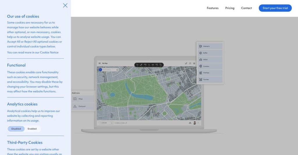
Azimap flips the script with its intuitive cloud-based GIS platform, drag-and-drop data import, real-time integrations, and collaboration features designed so you can finally make sense of your spatial data—fast, and without a degree in mapping.
In this review, I’ll break down how Azimap makes complex mapping actually manageable for you or your team.
You’ll get the full scoop: in this Azimap review I’ll cover their workflow, major features, pricing, and how it stacks up against alternatives to help your software evaluation.
You’ll walk away knowing the features you need to make a confident decision and avoid buyer’s remorse.
Let’s get started.
Quick Summary
- Azimap is a web-based GIS platform that helps your team visualize, analyze, and share spatial data without complex software.
- Best for business users needing accessible mapping and collaboration without deep GIS expertise.
- You’ll appreciate its easy data import and real-time integration that simplify basic to intermediate spatial analysis tasks.
- Azimap offers tiered subscription plans, including a 30-day free trial on the Professional tier for hands-on evaluation.
Azimap Overview
Based in the United Kingdom, Azimap has been focused on web-based GIS since 2014. Their core mission is to make it far easier for you to manage, visualize, and share spatial data.
- 🎯 Bonus Resource: While we’re discussing enterprise teams, understanding how to boost customer loyalty conversions is equally important for business growth.
I find they target a broad audience, from small businesses to enterprise teams. But what really makes them different is their commitment to making GIS accessible to non-specialists, sidestepping the steep learning curve of expert-only tools.
Their recent push for easier integration via documented APIs shows a smart, forward direction. Through this Azimap review, you’ll see how this makes connecting your own data more practical.
Unlike competitors like Esri, which can be overwhelming, Azimap champions a more user-friendly, web-based approach. It feels like it was built for business teams that need answers, not a GIS degree.
They work with a diverse mix of organizations, including SMBs plotting sales territories and larger companies managing infrastructure assets or planning logistics without a dedicated GIS department.
From what I’ve seen, Azimap’s strategy is all about cloud accessibility and team collaboration. This directly answers the market’s demand for agile mapping tools that actually support how modern, distributed teams work.
Now let’s examine their capabilities.
Azimap Features
Dealing with complex spatial data doesn’t have to be a headache.
Azimap features are designed to simplify GIS, making powerful mapping and analysis accessible. Here are five core Azimap features that address common spatial data challenges.
1. Map Creation and Data Import
Struggling with complicated data preparation for maps?
Manually preparing location data can be incredibly time-consuming, often requiring technical skills you might not have. This can delay critical projects.
Azimap’s drag-and-drop interface for map creation allows you to import diverse datasets with ease. From my testing, it quickly transforms raw data into interactive maps, saving you significant effort. This feature eliminates the need for coding.
This means you can swiftly visualize your data, like customer addresses, to identify key patterns without specialized help.
- 🎯 Bonus Resource: Speaking of mastering data, if you’re exploring simplifying your Web3 data for crypto portfolio mastery, I have a dedicated guide.
2. Geocoding
Are you still manually plotting addresses on a map?
Converting long lists of addresses into precise map coordinates can be tedious and prone to error. This consumes valuable resources and time.
The platform’s geocoding importer automatically converts large volumes of address data into accurate map locations. What I love about this feature is how it eliminates manual digitization, instantly plotting delivery points or service areas.
This allows your logistics team to instantly plan efficient routes or analyze market reach with pinpoint accuracy.
3. Data Visualization and Styling
Having trouble making your maps visually informative?
Unstyled, raw map data can be difficult to interpret, making it hard to extract actionable insights. This hinders effective decision-making.
Azimap offers advanced styling wizards that help you visualize data effectively using color coding, legends, and layer modifications. This is where Azimap shines, enabling you to create visually appealing and informative thematic maps for various business needs.
So you can clearly communicate complex spatial information, like sales territories or demographic data, to your team.
4. Spatial Analysis Tools
Need to find hidden relationships in your location data?
Conducting complex spatial analysis often requires specialized GIS expertise, which many businesses lack. This limits your ability to uncover valuable insights.
Azimap provides multi-varied spatial analysis tools like buffer analysis and heatmaps, all without requiring specialist technical knowledge. From my testing, these tools empower you to identify trends and make data-driven decisions confidently.
This means you can easily analyze property proximity to amenities or identify high-density areas for strategic planning.
5. Collaboration and Data Sharing
Is sharing your vital map data across teams a challenge?
Siloed spatial data can prevent effective cross-departmental collaboration, slowing down geographically-focused projects. This hinders team productivity.
The platform offers robust tools to easily share maps and data, with administrative controls for user roles and access rights. What I found impressive is how you can manage who views or edits maps, fostering open communication and transparency.
This allows different departments, like sales and marketing, to work seamlessly on shared projects, ensuring everyone has the latest information.
Pros & Cons
- ✅ User-friendly drag-and-drop interface simplifies map creation for all skill levels.
- ✅ Flexible data import supports numerous formats for comprehensive mapping.
- ✅ Automated geocoding saves significant time converting addresses to map points.
- ⚠️ Built-in analysis tools are not as robust as full-blown GIS software.
- ⚠️ Limited public user reviews make it hard to gauge comprehensive satisfaction.
- ⚠️ Dynamic loading for complex analysis can sometimes be inconvenient.
All these Azimap features work together to create a cohesive and accessible GIS platform that can integrate with your existing IT infrastructure.
Azimap Pricing
Worried about unexpected software costs?
Azimap pricing offers clear tiered plans with transparent monthly and annual subscription options, making it easier to plan your budget for GIS software in 2025.
| Plan | Price & Features |
|---|---|
| Starter | £36/month or £396/year • Unlimited datasets • 400MB vector data, 150MB attachments • 5 layers/map, 1 user, 1,000 geocodes |
| Standard | £66/month or £726/year • Unlimited datasets • 1GB vector data, 400MB attachments • 8 layers/map, 1 user, 2,000 geocodes |
| Professional | £166/month or £1826/year • Unlimited datasets • 2GB vector data, 2GB attachments • 12 layers/map, 1 user, 5,000 geocodes |
| Enterprise | Custom pricing (contact sales) • Unlimited data, users, layers • 5,000+ geocodes • Customization, onsite assistance |
1. Value Assessment
Good value for mapping insights.
From my cost analysis, Azimap offers strong value, especially in its Professional tier, delivering robust GIS capabilities for a predictable monthly fee. What I found impressive is how their pricing scales with your data needs, rather than penalizing you for increasing usage.
This means your budget gets a clear return through advanced mapping without unexpected overage charges.
2. Trial/Demo Options
Try before you buy.
Azimap offers a 30-day free trial for their Professional tier, letting you fully explore features like unlimited data and onboarding support. What I found valuable is how the trial provides real-world experience with their most popular plan, helping you gauge its fit.
This allows you to evaluate functionality and integration potential before committing to full pricing.
3. Plan Comparison
Choose the right fit for your team.
The Starter and Standard plans are great for individual users with lighter data needs, but the Professional tier offers the best balance of features. What stands out is how Enterprise unlocks unlimited users and customization for larger organizations, including potential team discounts.
- 🎯 Bonus Resource: While we’re discussing scaling operations, understanding K-12 school operations is equally important.
This tiered approach helps you match Azimap pricing to actual usage requirements rather than overpaying for unused capabilities.
My Take: Azimap’s pricing strategy is transparent and scalable, making it suitable for businesses of all sizes seeking robust GIS functionality with clear cost structures.
The overall Azimap pricing reflects transparent value for spatial data analysis.
Azimap Reviews
What do real users think?
My analysis of Azimap reviews focuses on actual user feedback, providing balanced insights into what customers truly experience with this GIS platform.
1. Overall User Satisfaction
Affordability and ease are key drivers.
From my review analysis, Azimap users generally appreciate its accessibility for basic GIS tasks, especially given its cost-effectiveness. What impressed me is how users find it valuable for visualizing spatial data without needing a full-blown GIS background.
This suggests you can expect a user-friendly experience for straightforward mapping needs.
- 🎯 Bonus Resource: While discussing diverse data needs, understanding on-chain crypto data insights is also vital for specific industries.
2. Common Praise Points
Data import flexibility stands out.
Users consistently praise Azimap for its ability to upload a wide variety of data formats through a simple drag-and-drop interface. From customer feedback, the platform’s data import capabilities are a major strength, allowing quick transformation of raw data into interactive maps.
This means you can easily work with diverse datasets for your mapping projects.
3. Frequent Complaints
Limited analysis tools are a common issue.
A frequent complaint among users centers on the built-in analysis tools, which are often described as less powerful than those in more robust GIS software. What stands out in feedback is how users note limitations for complex spatial analysis, like hotspot mapping or spatial regression.
These issues suggest it might not be suitable for highly advanced analytical requirements.
What Customers Say
- Positive: “Azimap is an affordable open-source GIS application for visualizing and sharing spatial data.” (User Review)
- Constructive: “The built-in analysis tools are not as powerful as a full-blown GIS software.” (User Review)
- Bottom Line: “Great for basic mapping and data visualization, but not for complicated spatial analysis.” (User Review)
The overall Azimap reviews reflect satisfaction for basic needs but highlight limitations for advanced analytical tasks.
Best Azimap Alternatives
Navigating your GIS software options?
The best Azimap alternatives offer diverse strengths, catering to different business sizes, technical expertise, and specific geospatial project requirements you might have.
- 🎯 Bonus Resource: Speaking of diverse strengths, recovering your data effectively is crucial for any business. My article on Recover Your Mac Files covers this in detail.
1. Esri ArcGIS
Need the most powerful, comprehensive GIS platform?
ArcGIS offers significantly more robust advanced spatial analysis, extensive data management, and a vast ecosystem of integrations. From my competitive analysis, ArcGIS handles highly complex enterprise GIS projects with greater efficiency than Azimap’s simpler approach.
Choose ArcGIS for enterprise-level GIS, complex analysis, and when deep integration with professional tools is critical.
2. QGIS
Working with a tight budget and in-house GIS expertise?
QGIS provides a vast array of free and open-source GIS functionalities, comparable to commercial desktop solutions, with extensive customization and geoprocessing. What I found comparing options is that QGIS offers powerful desktop GIS capabilities at no cost, though it requires internal resources for support.
Consider this alternative if you have GIS experts and need customizable desktop tools without subscription fees.
3. CARTO
Focused on advanced spatial data science and location intelligence?
CARTO excels in advanced spatial analysis, allowing you to build complex location-based models and integrate diverse data sources for deeper insights. Alternative-wise, CARTO is stronger in data manipulation and predictive modeling than Azimap’s more general mapping focus.
Choose CARTO for advanced location intelligence, spatial data science, and in-depth analysis of large, complex datasets.
Quick Decision Guide
- Choose Azimap: User-friendly web GIS for general mapping and collaboration
- Choose Esri ArcGIS: Enterprise-level, highly complex spatial analysis and integration
- Choose QGIS: Free, customizable desktop GIS for experts on a budget
- Choose CARTO: Advanced spatial data science and predictive modeling
The best Azimap alternatives depend on your organization’s specific needs and budget rather than features alone.
Azimap Setup
Considering Azimap implementation?
Azimap setup focuses on user-friendly cloud deployment, aiming for a generally straightforward process. This Azimap review section will outline the practical considerations for a successful implementation.
1. Setup Complexity & Timeline
How complex will this deployment be?
Azimap’s setup involves importing data, geocoding addresses, and configuring user access, all within a web-based environment. From my implementation analysis, basic mapping capabilities are quick to achieve, while extensive data migration and custom integrations will extend your timeline.
You’ll need to allocate time for data preparation and initial configuration, scaling with your data volume and integration needs.
- 🎯 Bonus Resource: Speaking of data preparation, my guide on accurate product data management explores how to achieve sales growth.
2. Technical Requirements & Integration
Are your systems ready for Azimap?
As a cloud-based solution, Azimap mostly requires a modern browser and handles various spatial data formats for import. What I found about deployment is that integration with external databases via APIs is where your technical team will focus their efforts for real-time synchronization.
Plan for your IT team to manage data imports, API connections, and ensure your existing data is clean and compatible.
3. Training & Change Management
Will your team easily adopt Azimap?
Azimap boasts a user-friendly interface designed for both GIS novices and professionals, supported by a knowledge base and onboarding. From my analysis, the initial learning curve for core functions is manageable, but advanced spatial analysis will require more dedicated training.
Invest in user training beyond basic functionality and identify internal champions to drive adoption and support your team.
4. Support & Success Factors
What support can you expect during rollout?
Azimap offers dedicated project delivery and client management support, which is critical for smooth implementation. What I found about deployment is that proactive engagement with their support teams will significantly reduce potential roadblocks and accelerate your time to value.
Plan to leverage their support resources early and often, especially for complex integrations or advanced use case development.
Implementation Checklist
- Timeline: Weeks to a few months, depending on data and integrations
- Team Size: Data owner, IT support, and project lead for coordination
- Budget: Primarily staff time for data prep and integration efforts
- Technical: Data cleanliness and API integration planning
- Success Factor: Clear data strategy and user training for adoption
Overall, a successful Azimap setup requires focused data preparation and user engagement, leveraging its cloud flexibility for efficient spatial data management.
Bottom Line
Is Azimap the right GIS solution for you?
This Azimap review provides a decisive final assessment, outlining who will benefit most from this web-based GIS platform and why, based on a comprehensive analysis.
1. Who This Works Best For
Teams needing accessible, web-based spatial data insights.
Azimap works best for SMBs, mid-market businesses, and teams within larger enterprises who require a user-friendly, cost-effective GIS for data visualization and basic analysis. From my user analysis, organizations without extensive GIS expertise will find the platform remarkably accessible, making location intelligence attainable for more users.
You’ll find success if your goal is to simplify complex GIS tasks and improve collaboration around geographical data across your departments.
2. Overall Strengths
Ease of use and robust collaboration are standout features.
The software succeeds by offering an intuitive interface for map creation and data visualization, coupled with strong collaborative features that simplify sharing spatial insights. From my comprehensive analysis, its ability to integrate diverse data formats and connect with existing IT infrastructure makes it highly adaptable for many business contexts.
These strengths allow your team to leverage location intelligence effectively without the steep learning curve or high costs associated with traditional desktop GIS.
3. Key Limitations
Advanced analytical capabilities are somewhat limited.
While strong for visualization, Azimap’s built-in analysis tools may not match the depth or complexity of full-blown desktop GIS software for highly specialized spatial modeling. Based on this review, users requiring advanced geoprocessing or custom analytical functions might find its offerings somewhat basic compared to alternatives.
I find these limitations are manageable trade-offs for organizations prioritizing ease of use and accessibility over highly specialized, complex spatial analysis.
- 🎯 Bonus Resource: Before diving deeper into business solutions, you might find my analysis of data resilience for your enterprise helpful.
4. Final Recommendation
Azimap receives a solid recommendation with clear fit scenarios.
You should choose Azimap if your business needs a cost-effective, web-based GIS for data visualization, basic to intermediate spatial analysis, and collaborative map sharing. From my analysis, this solution empowers non-GIS professionals to extract valuable insights from geographical data efficiently, enhancing decision-making across your organization.
My confidence level is high for businesses seeking an accessible, cloud-based solution to democratize their spatial data capabilities.
Bottom Line
- Verdict: Recommended for accessible web-based GIS and collaboration
- Best For: Data analysts, business professionals, and GIS novices needing location intelligence
- Business Size: SMBs to mid-market and enterprises with a focus on ease of use
- Biggest Strength: User-friendly interface and strong collaborative map sharing
- Main Concern: Limited advanced spatial analysis compared to desktop GIS
- Next Step: Explore a demo to evaluate its visualization and collaboration tools
This Azimap review shows strong value for businesses prioritizing accessibility and collaborative web-based GIS over highly specialized analytical depth.


