Moving spatial data is a nightmare.
If you’re dealing with massive datasets stuck in cloud data warehouses, traditional GIS software can slow you down and drain your resources. That’s likely why you’re exploring what CARTO might fix for your team.
In my analysis of CARTO, what stood out is that lost productivity from inefficient data movement hurts real project deadlines more than you’d expect.
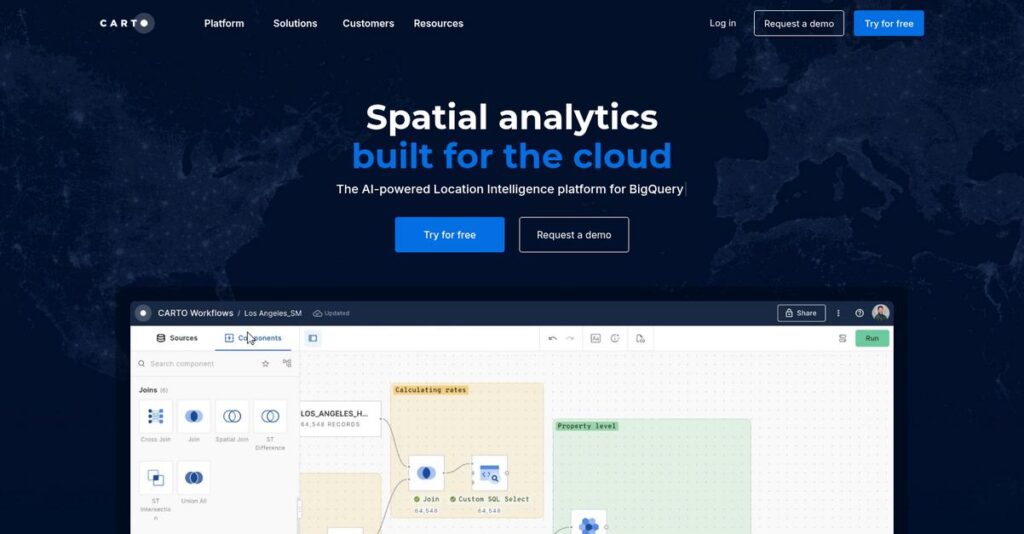
CARTO flips the usual script—connecting straight to your Snowflake, BigQuery, or Redshift so your data never leaves the warehouse. My research shows their platform offers everything from no-code spatial analysis to curated datasets and advanced SQL tools, changing how your team works with geospatial data.
Here’s what I’ll cover in this review: how CARTO helps you analyze data in place instead of forcing you through slow, manual exports and workflow bottlenecks.
In this CARTO review, I’ll break down features, pricing, user experience, pros and cons, and stack it up against alternatives to help with your evaluation.
You’ll find the features you need to speed up analysis, cut out workflow pain, and make your decision easier.
Let’s dive into the analysis.
Quick Summary
- CARTO is a cloud-native Location Intelligence platform that enables spatial analysis directly within your cloud data warehouse.
- Best for mid-market and enterprise teams embedding complex spatial analysis into BI workflows.
- You’ll appreciate its ability to empower both technical and non-technical users with integrated, no-code to advanced analysis tools.
- CARTO offers a free tier, a 14-day trial, individual plans at $199/month, and custom enterprise pricing with sales contact required.
CARTO Overview
CARTO has been a player in location intelligence since 2012, with its main headquarters in New York. I think their core mission is straightforward: let you analyze spatial data directly in your cloud data warehouse.
What sets them apart is a clear focus on enterprise data teams. Instead of being a standalone GIS, they integrate with your existing data stack, letting you query massive datasets in place without slow ETL processes.
Their significant 2021 funding round really accelerated this cloud-native strategy. For this CARTO review, you can see the impact in how robust their Snowflake and BigQuery integrations have now become.
Unlike developer-focused tools like Mapbox, CARTO is an end-to-end platform. It provides advanced analysis, not just map-making, giving your data scientists and business analysts a shared, powerful environment.
They work with large enterprises and data-forward mid-market firms. I see them fitting best with companies that already have analysts and data scientists who need better spatial tools for their daily work.
You’ll notice their entire business strategy is built around the modern data stack. They’re betting that you want to centralize analysis in your cloud warehouse, which aligns perfectly with current enterprise data trends.
Let’s dive into their feature set.
CARTO Features
Spatial data analysis feels too complex and slow.
CARTO is a cloud-native platform focused on bringing spatial analysis directly to your data warehouse. These are the five core CARTO solutions that can help you unlock powerful location intelligence from your existing data.
- 🎯 Bonus Resource: Before diving deeper, you might find my analysis of Android Data Recovery Software helpful.
1. The CARTO Platform
Moving massive spatial data is a nightmare?
Extracting large datasets from your data warehouse to a separate GIS system can be incredibly slow and costly. This often creates security and scalability headaches.
The CARTO Platform connects directly to your cloud data warehouse, processing queries right where your data lives. From my testing, this eliminates the need for costly data movement, making analysis faster and more secure. This foundational solution acts as your central hub.
This means you can leverage your existing data infrastructure efficiently, gaining insights without compromising data integrity or performance.
2. CARTO Builder
Can’t create maps without coding expertise?
Business analysts often struggle to visualize spatial data effectively without relying on developers. This can bottleneck insight sharing and decision-making.
CARTO Builder provides an intuitive, web-based, drag-and-drop interface for creating interactive maps and dashboards. What I found really impressive is how quickly you can transform raw data into compelling visualizations with various map types and widgets. This solution empowers non-technical users.
So you can rapidly explore and communicate complex spatial insights visually, democratizing powerful mapping for your entire team.
3. CARTO Workflows
Is advanced spatial analysis stuck in expert hands?
Complex spatial data preparation and analysis tasks typically require specialized coding skills. This often limits who on your team can perform sophisticated analysis.
CARTO Workflows is a visual, no-code/low-code tool that automates multi-step spatial pipelines. This is where CARTO shines, as you can design intricate analyses by dragging and connecting components, making advanced tasks accessible. This solution democratizes complex processes.
The result is your team can automate routine spatial processes, freeing up data engineers and allowing more team members to derive value from location data.
4. Analytics Toolbox for Cloud Data Warehouses
Do data scientists need better in-warehouse spatial tools?
Data scientists often find native cloud data warehouse capabilities insufficient for advanced spatial functions. This forces them to move data, reducing efficiency and security.
The Analytics Toolbox offers a robust library of User-Defined Functions (UDFs) directly within your warehouse. This solution extends SQL with powerful capabilities like routing, spatial indexing, and advanced statistics, allowing complex models to run efficiently.
This means your data scientists can perform deep spatial analysis at scale, leveraging the full power of your cloud data warehouse without cumbersome data transfers.
5. CARTO Data Observatory
Finding external spatial data is a headache?
Sourcing, licensing, and integrating quality third-party spatial datasets can be an incredibly time-consuming and costly process. This often delays critical analysis projects.
The CARTO Data Observatory is a curated marketplace with over 12,000 spatial datasets ready for immediate use. You can easily browse, subscribe to, and instantly access premium data like demographics or human mobility directly within the platform. This solution simplifies data enrichment.
So you can effortlessly enrich your internal data with crucial external context, leading to richer insights and more informed business strategies.
Pros & Cons
- ✅ Cloud-native data warehouse integration ensures performance.
- ✅ Powerful Builder empowers intuitive, interactive map creation.
- ✅ Workflows automate complex spatial analysis for all users.
- ⚠️ Steep learning curve for advanced features requires time.
- ⚠️ Enterprise pricing may be a significant financial commitment.
- ⚠️ Transition from legacy platform presented some initial adjustments.
You’ll appreciate how these CARTO solutions work together to create a cohesive spatial intelligence ecosystem that leverages your existing cloud data infrastructure. This unified approach makes advanced location analytics more accessible and scalable.
CARTO Pricing
Understanding what you’ll actually pay can feel complicated.
CARTO pricing for teams and enterprises operates on a custom quote model, offering you tailored solutions but requiring direct contact for detailed cost information. This approach ensures your budget aligns with specific needs.
Cost Breakdown
- Base Platform: Custom quote (likely starts low-to-mid five-figures annually for small teams)
- User Licenses: Influenced by user count
- Implementation: Varies by implementation scope
- Integrations: Varies by complexity of connections
- Key Factors: Number of users, processing volume (credits), support level, SSO, specific features
1. Pricing Model & Cost Factors
Understanding their unique pricing model.
CARTO’s enterprise pricing is custom-quoted, influenced by factors like user count, processing volume (credits), and required support levels. This adaptable structure means you get a solution tailored to your data needs, avoiding generic plans. Their credit-based system also accounts for computations and data enrichment.
Budget-wise, what I found regarding pricing is that this model helps you align your monthly costs directly with your business size and operational complexity. This ensures efficient budget allocation.
- 🎯 Bonus Resource: While we’re discussing operational complexity, understanding how a digital adoption platform can personalize onboarding and retain users is equally important.
2. Value Assessment & ROI
Considering the value you receive.
CARTO emphasizes a cloud-native approach, processing data directly in your existing warehouse. This significantly reduces data movement costs and latency, offering strong ROI compared to traditional GIS systems. From my cost analysis, this means your investment directly enhances existing infrastructure, avoiding costly data duplication for better performance.
The result is your budget gains better visibility and predictable expenses over time, providing substantial long-term savings for your spatial analysis needs.
3. Budget Planning & Implementation
Planning your CARTO budget.
Beyond the base custom pricing, you must factor in potential costs for professional services, training, and extensive integrations if your setup is complex. What I found regarding pricing is you’ll need to clarify credit overage charges during sales conversations to avoid unexpected costs.
So for your business, you can expect to allocate a significant budget upfront for smooth deployment and to manage your total cost of ownership effectively.
My Take: CARTO’s pricing strategy prioritizes flexibility and a custom fit, making it ideal for mid-to-large enterprises needing sophisticated spatial analysis integrated into their cloud data strategy.
The overall CARTO pricing reflects customized enterprise software value aligned with your needs.
CARTO Reviews
What do actual users really think?
To give you an honest perspective, I dove deep into CARTO reviews from real users across platforms like G2 and Capterra, analyzing countless pieces of feedback to understand their experiences.
1. Overall User Satisfaction
A mixed, yet positive picture.
From my review analysis, CARTO averages around 4.4 out of 5 stars, showing strong overall user sentiment. What I found in user feedback is a clear appreciation for its powerful capabilities, though a steep learning curve for advanced features tempers perfect scores. Many users find it incredibly powerful.
- 🎯 Bonus Resource: Speaking of diverse applications, if you’re exploring ways to elevate customer interactions, my article on automatic call distribution software provides insights.
Satisfaction hinges on your technical background and application needs, balancing powerful features with a steeper learning curve.
2. Common Praise Points
Users rave about visualization.
What stands out in customer feedback is consistent praise for CARTO’s powerful visualization tools, especially CARTO Builder. Users frequently highlight its ability to transform raw data into high-quality, insightful maps effortlessly. Cloud data warehouse integration receives high marks for performance and security.
This means you gain rapid, visually compelling data exploration without complex data movement, enhancing team collaboration easily.
3. Frequent Complaints
Learning curve is the main hurdle.
Review-wise, the most frequent complaint centers on CARTO’s learning curve, particularly for mastering Workflows and the Analytics Toolbox. While Builder is intuitive, users report a significant time investment is required for full proficiency. Enterprise pricing is also a concern for smaller operations.
These challenges are often about initial setup and advanced usage, not fundamental flaws, making them manageable with proper commitment.
What Customers Say
- Positive: “CARTO allowed us to take location intelligence to the next level, facilitating collaboration and helping us understand our data and customers better.”
- Constructive: “There’s a fairly steep learning curve beyond basic visualizations. Documentation is good, but finding what you need requires digging.”
- Bottom Line: “A powerful platform for spatial analysis directly in your data warehouse, though it demands a learning commitment for full mastery.”
Overall, CARTO reviews paint a picture of a robust, cloud-native platform with significant power. What you should know is that review patterns offer credible insights into its strengths and required investment.
Best CARTO Alternatives
Overwhelmed by CARTO’s many options?
Choosing the best CARTO alternatives requires understanding your specific needs. From my competitive analysis, the market offers several strong contenders, each excelling in different scenarios for your business.
- 🎯 Bonus Resource: Speaking of safeguarding your data, my guide on best anti spyware software can provide further insights.
1. Esri (ArcGIS Platform)
Need a traditional GIS powerhouse?
Esri remains the industry leader for large organizations with deep GIS infrastructure and specialized desktop needs. What I found comparing options is that Esri provides exhaustive desktop GIS capabilities, making it ideal for established legacy systems. However, CARTO is far more cloud-native and modern for today’s data stack.
You should choose Esri if your organization has a dedicated GIS department and requires highly specialized desktop GIS functions.
2. Mapbox
Building custom, interactive web maps?
Mapbox is a developer-first platform for embedding beautiful, high-performance custom maps into web and mobile applications. Alternative-wise, Mapbox excels at front-end map visualization, focusing on developer APIs rather than deep spatial analytics, which CARTO prioritizes for your data.
Choose Mapbox when your priority is visually stunning basemaps for consumer-facing apps, not back-end data analysis.
3. Google Maps Platform
Integrating basic mapping into applications?
Google Maps Platform offers unparalleled global data for routing, geocoding, and place searches via its APIs. From my competitive analysis, this alternative is best for leveraging Google’s extensive data for simple mapping functions, but it can get pricey at high volumes for your usage.
You’ll want to consider Google Maps Platform when adding basic map, routing, or address lookup to an existing application.
4. Tableau / Power BI
Spatial analysis as part of broader BI?
Tableau and Power BI are leading BI platforms that offer basic mapping capabilities as part of their broader analytics suites. What I found comparing options is that these alternatives suit simple spatial needs within a non-spatial business dashboard, not advanced dedicated analysis.
For your specific situation, choose these when spatial analysis is a minor component of your overall business intelligence strategy.
Quick Decision Guide
- Choose CARTO: Analyzing proprietary data within your cloud data warehouse.
- Choose Esri: Dedicated GIS departments with legacy systems and desktop needs.
- Choose Mapbox: Developer-focused custom web and mobile map embedding.
- Choose Google Maps Platform: Basic mapping, routing, and address lookup in applications.
- Choose Tableau / Power BI: Simple mapping as part of broader business intelligence.
The best CARTO alternatives depend on your specific business scenarios and core priorities rather than just feature lists. Carefully evaluate your use case.
Setup & Implementation
Ready for a smooth software transition?
Your CARTO review journey includes understanding its real-world implementation. This isn’t just about features; it’s about practical deployment and adoption. I’ll guide you through what to realistically expect.
1. Setup Complexity & Timeline
Deployment varies significantly here.
For individual plans, CARTO implementation is quick: sign up, connect your cloud data warehouse, and begin building. Enterprise deployments, however, demand more planning around user roles and data governance. What I found about deployment is that your timeline scales with complexity and existing data infrastructure, requiring careful scoping.
You’ll want to prepare by understanding your current data setup and defining clear enterprise security and governance requirements upfront.
2. Technical Requirements & Integration
Technical setup can be critical.
CARTO shines with its cloud-native integrations, primarily connecting directly to your existing data warehouses like Snowflake or BigQuery. This eliminates data movement, but implementation-wise, you need your data ready and organized within a supported warehouse. APIs and SDKs also support custom application embedding.
Your IT team needs to ensure your cloud data warehouse is optimized and accessible. Plan for custom integrations using CARTO’s robust APIs and SDKs.
3. Training & Change Management
User adoption requires focus.
While CARTO Builder’s interface is intuitive for quick wins, mastering the full power of the Analytics Toolbox or Workflows demands dedicated learning. From my implementation analysis, a significant learning curve exists for advanced features, despite comprehensive documentation. Budget time for this.
Invest in structured training programs for advanced users. Appoint internal champions and define clear use cases to help teams adopt sophisticated spatial analysis.
4. Support & Success Factors
Support can make or break it.
CARTO offers standard and premium support, generally described as responsive and knowledgeable in user reviews. However, implementation-wise, resolving highly technical issues can take time. Proactive communication and clear problem definition are crucial for efficient resolution during deployment.
Establish clear communication with CARTO support. Define internal project leads who can troubleshoot initial issues and escalate complex problems efficiently.
Implementation Checklist
- Timeline: Weeks to months for enterprise, days for individual users
- Team Size: IT/data team for enterprise; business users for individual setup
- Budget: Factor in advanced training and potential professional services
- Technical: Cloud data warehouse optimized; API/SDK integration readiness
- Success Factor: Clear data strategy and commitment to advanced user training
Overall, CARTO implementation varies from straightforward for individuals to a more strategic project for enterprises. Success hinges on your planning, technical readiness, and commitment to training. Proper preparation ensures successful spatial insights.
Who’s CARTO For
Is CARTO the right spatial analytics fit?
This CARTO review analyzes who benefits most from its advanced location intelligence platform. I’ll guide you through specific business profiles, team sizes, and use cases to help you quickly assess your fit.
1. Ideal User Profile
Your business thrives on location intelligence.
CARTO is ideal for mid-market to enterprise companies where location data drives core business strategy. From my user analysis, organizations with modern cloud data infrastructure immediately realize value. It’s built for data scientists, analysts, and GIS specialists needing powerful tools to transform spatial insights efficiently.
You’ll thrive if spatial data is a critical asset and you already leverage cloud data warehouses for comprehensive analytical needs.
2. Business Size & Scale
Scaling location intelligence effectively.
CARTO targets mid-market to enterprise customers with established data teams. What I found about target users is that smaller organizations might find pricing a commitment, but larger enterprises appreciate its depth and flexibility.
You’ll fit if your business has existing cloud data infrastructure and specialized personnel to fully leverage CARTO’s advanced capabilities effectively.
3. Use Case Scenarios
Complex spatial analysis, simplified.
CARTO excels when you need complex spatial analysis on large, private datasets already in your cloud data warehouse. This includes site selection, risk assessment, or route optimization. From my analysis, the platform empowers both technical and non-technical users to collaborate efficiently.
You’ll find this works best when your specific workflows demand deep spatial insights directly from your existing cloud data.
4. Who Should Look Elsewhere
Not every mapping need fits.
If your mapping needs are very simple, like embedding basic maps on a website, CARTO might be overkill. From my user analysis, companies without a cloud data warehouse strategy will struggle to integrate with its core capabilities.
Consider simpler, more cost-effective mapping solutions if your requirements don’t extend to complex spatial analysis or advanced cloud data integration.
Best Fit Assessment
- Perfect For: Mid-market to enterprise companies viewing location as core strategy.
- Business Size: Mid-market to enterprise, established data/GIS teams.
- Primary Use Case: Complex spatial analysis on large, cloud data warehouse datasets.
- Budget Range: Requires enterprise-level investment; expect significant commitment.
- Skip If: Only basic mapping needed or no cloud data warehouse integration.
Ultimately, who should use CARTO comes down to your strategic reliance on location data and existing cloud data infrastructure. It’s a powerful investment if your needs align with advanced spatial analytics.
Bottom Line
CARTO delivers powerful location intelligence.
This CARTO review reveals a powerful cloud-native Location Intelligence platform that excels for specific enterprise needs. My assessment cuts through the features to provide a clear, actionable recommendation tailored for your business.
- 🎯 Bonus Resource: If you’re also looking into effective data acquisition, my guide on 9+ Best Web Scraping Tools can provide valuable insights.
1. Overall Strengths
CARTO nails spatial visualization exceptionally well.
The software shines by allowing users to visualize large datasets directly from cloud data warehouses, ensuring performance and security. From my comprehensive analysis, its intuitive Builder UI simplifies complex mapping while powerful Workflows democratize advanced spatial analysis for non-coders.
These strengths directly translate into more insightful, collaborative data exploration and operational efficiency for your data-driven teams.
2. Key Limitations
Learning curve and pricing present hurdles.
Mastering CARTO’s full capabilities, particularly its Analytics Toolbox and intricate Workflows, demands a significant time investment. Based on this review, users report a fairly steep learning curve for anything beyond basic visualizations, and enterprise pricing can be a substantial commitment for smaller budgets.
These limitations are important considerations for your team’s readiness and budget, but they are manageable trade-offs for the right enterprise.
3. Final Recommendation
CARTO earns a strong conditional recommendation.
You should choose this software if your mid-market or enterprise organization has established data teams eager to embed cloud-native spatial analysis. From my analysis, CARTO is ideal for data-driven enterprises prioritizing in-place analysis and high-quality geospatial visualization within their existing cloud data stack.
My recommendation comes with high confidence for businesses prepared to invest in robust spatial intelligence capabilities and user training.
Bottom Line
- Verdict: Recommended with reservations
- Best For: Mid-market & enterprise data teams needing cloud-native spatial analysis
- Biggest Strength: Powerful cloud-native spatial visualization & integration
- Main Concern: Significant learning curve for advanced features
- Next Step: Request a tailored demo to assess organizational fit
This comprehensive CARTO review clearly demonstrates significant value for the right organizations seeking advanced spatial insights. I am confident this final assessment will guide your decision-making process effectively.


